.jpg)
.jpg)
.jpg) There was one last lighthouse and we took a road out towards where the map showed it to be. We wound up in the town of Cannon Beach. It was a very "yuppie" kind of town with cars lining the streets, parking lots filled, and people everywhere. We managed to find a parking spot after a couple of circuits around, then started looking for somewhere affordable to eat. We found a pizza place that sold by the slice.
There was one last lighthouse and we took a road out towards where the map showed it to be. We wound up in the town of Cannon Beach. It was a very "yuppie" kind of town with cars lining the streets, parking lots filled, and people everywhere. We managed to find a parking spot after a couple of circuits around, then started looking for somewhere affordable to eat. We found a pizza place that sold by the slice.While we ate, we tried to figure out how to get to the last lighthouse. We used Clay's phone to look up Tillamook Rock and it turned out that the lighthouse is about 3 miles off the coast on a big rock. So we weren't going to drive out to that one.
We continued North from Cannon Beach but after about an hour, I was feeling tired so we decided to pull over and take a short break. We were up on a bluff with a pullout. I laid down on the retaining wall and grabbed a short cat nap.

.jpg)

I caught my second wind, which was a good thing because we still had a long way to go. Finally we arrived in Astoria. We rode over the bridge into Washington State. We hoped to find a good "Welcome to Washington" sign, but the only sign was a little thing hung in the middle of the bridge and we sure weren't going to try stopping for pictures. This was as far North as we were riding, so after crossing the bridge, we rode back over the bridge we turned East toward Portland..jpg)
.jpg)
By the time we rode the 100 miles into Portland it was 5:30 and the middle of rush hour. We got on the 405 freeway and crossed the city with very few delays coming out on I-5 towards Salem and Corvallis. We checked into the KOA just outside of Corvallis, then rode into town to find somewhere to eat..jpg)
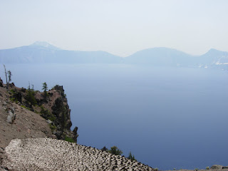
The next morning we got on the road by 7:00 heading South East towards Crater Lake national monument. We passed some beautiful lakes and stopped for a few pictures by one and to see just how cold the water is. It is much warmer than I thought it would be, maybe in the low 60s. As we continued South, the air slowly got more hazy with smoke from the California fires. By the time we pulled into the first overlook, there was a heavy haze in the air. It was a beautiful spot, but it was hard to see much from the smoke.
.jpg)
.jpg)
We drove around the rim to some other scenic vistas, then stopped at the visitor's center for lunch. We paid more for the sandwiches and drinks than we did for the great meal the night before.After lunch we looked at each other and realized it was kind of the end of the trip, and from here we were headed home. It was kind of a sad moment.We rode down off the volcano and through Klamath. It was still early in the day so we continued on toward a small town called Lakeview. We got to Lakeview by 4:30 but we were both so tired and hot that we decided not to try to make it to Winnemucca which was another 200 miles. We checked into the Best Western then went to unload the bikes. By the time we were finished unloading and cooling down, the hotel was sold out and so were the other hotels. We'd gotton one of the last available rooms or we'd have been forced to ride on to Winnemucca.We ate dinner at the dining room in the hotel next door and got a wonderful meal. We then called it a night cuz tomorrow was going to start early.
No comments:
Post a Comment